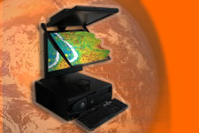
3D Topography- RGI- 11 Project afgesloten
3d_topo_v15.doc
original plan 3D topograpy, November 2004
3D_topo_2005_v5.doc
plan phase 1, June 2005
3Dtopo_2efase_v5.doc
plan phase 2, December 2005
top-up project proposal RGI 011, 3D topography, comparing different 3D models, 31 oktober 2006
Top-up RGI-011-A 3D Topography Comparing different 3D models
Top-up RGI-011-B 3D Topography
Eindrapportage RGI 011
24 September 2009:
ITC Research Award 2009 awarded to Sander Oude Elberink for his article link
" 3D information extraction from laser point clouds covering complex road junctions " link
Project home 3D topo
Space for Geo-information, project RGI-011 ‘3D topography’:
There is an increasing need for real 3D topography due to a broad
range of applications. Four prototypical applications are analysed
with regard to the user wishes and the resulting 3D model requirements.
On this basis, a new 3D topographical product model is further developed
together with new methods and techniques and for data collection,
storage and analysis. The project is spread over the period 2005-2008
and consists of the following sub-projects:
SUB1 Research on accessibility and user requirements of 3D topographic
data and systems
SUB2 3D topographic data model
SUB3 3D conversion and acquisition techniques
SUB4 3D DBMS and analysis
SUB5 Knowledge distribution and communication
Main project objective: Enforcing a major break-through in the
application of 3D Topography in corporate ICT environments due
to structural embedding of 3D methods and techniques.
Contact: Peter
van Oosterom
Some subpages are currently only available in Dutch. However,
most relevant publications are in English.
De RGI projecten zijn per 31 December 2008 afgerond. De website kan vooral als archief worden gezien van de geproduceerde projectresultaten, zoals rapporten, artikelen, test dataset, etc.
AWARD!
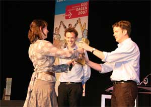
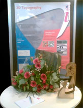
Het project '3D topografie' heeft tijdens de Nationale Geo-Innovatie Dagen (13 en 24 maart 2007 in de Van Nelle Ontwerpfrabriek te Rotterdam) de Geo-Innovatie Award 2007 in de categorie 'Wetenschap' gewonnen. RGI programma directeur Jacqueline Meerkerk overhandigde een fraaie sculptuur, een koperachtige award met uitgespaarde 'RGI'-i met bolletje' en een bos bloemen aan de 3D topografie onderzoekers Sander Oude Elberink (ITC) en Friso Penninga (TU Delft). De bezoekers aan de Nationale Geo-Innovatie Dagen konden via een stemformulier aangeven naar welk RGI project hun voorkeur uitging. Het moge duidelijk zijn dat de betrokken onderzoekers zeer vereerd zijn met deze
publieksprijs!
--------------
Sander Oude Elberink
ISPRS prize for the best papers by young authors XXI ISPRS Congress,
Beijing, July 1-13, 2008
Categorie: overige resultaten/prijs
RGI-011-126
--------------
RGI-011-62
Redactie Computable
Geo-Awards uitgereikt (in Dutch)
In: Computable, Volume 40, 12, p. 14

From 12-14 December 2007, TU Delft will host 3D GeoInfo 07, the 2nd International Workshop on 3D Geo-Information: Requirements, Acquisition, Modelling, Analysis, Visualisation. The Workshop aims at bringing together international state-of-the-art research in the field of 3D geo-information. It offers an interdisciplinary forum to researchers in the closely related fields of:
- Data collection and modelling: advanced approaches for 3D data collection, reconstruction and methods for representation.
- Data management: topological, geometrical and network models for maintenance of 3D geo-information.
- Data analysis and visualisation: frameworks for representing 3D spatial relationships, 3D spatial analysis and algorithms for navigation, interpolation, etc. Advanced Virtual Reality and Augmented Reality visualisation.
The Workshop is intended as an interactive platform for both presentations on state-of-the-art research and discussions on open problems. The workshop will consist of a mixture of single-track presentations and discussion (PD) sessions and parallel working group (WG) sessions on specific themes (Requirements, Acquisition, Modelling, Analysis, Visualisation), according to the following format: current problems to be solved, potential solutions, and recommendations by WG (discussion under coordination of a chair and final presentation of the results at the closing plenary session). The presentations will be selected based on their quality by the scientific program committee (peer review of full papers).
* The 3D topography research on the front cover of the important German journal 'Photogrammetrie Fernerkundung Geoinformation'
3D topo top-up December 11, 2007
15.00-15.20: 11 /Report on their 3D world tour/ Jonathan Raper & Aiden Slingsby (City University London)